After Bhedaghat, Narmada continues to flow in the Jabalpur district for some distance. There is a place called Belpathar, where Raja Bali is said to have performed a Yagna – though a place called Bilthari a little downstream and in Narsinghpur district also claims this. There are several other ghats and temples like the Jhansi ghat, the Gora ghat, and Sarra Ghat where there is a temple of Sri Ramachandra and Sita. There is also Budhghat where ‘Budh’ is said to have done Tapasya to get rid of some deformities.
The river then enters the districts of Narsingpur and Narmadapuram (earlier known as Hoshangabad) , forming a beautiful fertile basin as the Vindhya and Satpura recede some distance away. This area is relatively more prosperous because of its soil yielding handsome agricultural produce.
Narsinghpur town which serves as the district headquarters, was earlier called Garadiya Kheda, and got its name due to the presence of a magnificent temple built by Jat Sardars in the eighteenth century dedicated to Lord Narsingh (also called Narsimha), one of the ten Avatars of Vishnu. The district has a good yield of milk and milk products. In this district there are several places which have gained importance after extensive archaeological explorations.
On Narmada several important places are located. One is the Gararu Ghat where there is a temple associated with Garuda – the vehicle of Vishnu; much later on the trajectory is another important place of Garudeshwar in Gujarat also associated with Garuda.
Not far from Gararu Ghat, there is a cave said to be associated with Sri Govindapada, the Guru of Sri Sankara, and also not afar, and a few miles from is a very grand complex of temples, ashrama and service institutions, founded by the late Sankaracharya of Dwarka, Revered Swami Swaroopananda Saraswati.
The river Harani, the longest tributary of Narmada, 188 km in length, which originates from the Vidhya plateau east of Jabalpur, meets her at Hirapur on the northern banks. A bit downstream, there is the Sagun Ghat on the southern banks where a tributary ‘Sher’, 229 km in length, originating from Seoni district and subsequently flowing in Narsinghpur district meets Narmada. On the other banks near the Sagun Ghat is a place called Putlikhoh where prehistoric paintings and sketches have been discovered.
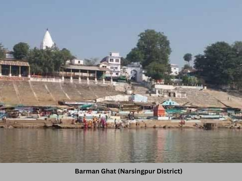
The grandest ghat in Narsingpur district, and indeed one of the most magnificent ones in entire Narmadakhand, is the ‘Barman Ghat’ – the name originating from ‘Brahma Ghat’ as Brahma is said to have performed ‘Tapasya’ at this spot. Some of the biggest ‘Melas’ (public fairs) take place at this Ghat on occasions of Poornima, Amavasya, and most importantly during ‘Makar Sankranti’ that goes for several weeks. The Barman Ghat is one of the three biggest ghats on the Narmada – the others being Maheshwar Ghat built by the great Ahilyabai Holkar and the Sethani Ghat in Narmadapuram. There is also a big riverine island on the Narmada in the Barman region which also has a magnificent temple. The Barman Ghat in its present form was largely developed by the Marathas. Ahilyabai Holkar also contributed significantly to this ghat, in the same manner as she did across whole of Narmadakhand and indeed across the length and breadth of the country.
Opposite to the Barman Ghat, which is on the northern banks, is the Chhoti Barman. This ghat too has many temples.
Just before the Barman Ghat is Saptadhara, also known as Satdhara, and is related to the legends of Mahabharata.
It is recorded that Mahatma Gandhi had crossed Narmada at Barman Ghat in 1933 and the boatmen refused to take him across unless they were allowed to worship his feet. The poor boatmen remembered it well that their ancestors had done the same thousands of years back while taking Sri Ramachandra across the Ganga. Gandhi, it is reported, was in great discomfiture, and after failed prolonged resistance, had to yield to their reverential persuasions.
Just downstream of Barman Ghat, on the northern banks is a place called Ram Ghat. It is said that Sri Ramachandra had visited there during a pilgrimage to the Narmadakhand while he was the king of Ayodhya.
In this area, is located Gadarwara, a tehsil town and a railway station on the Mumbai-Jabalpur-Mughalsarai railway line and an important trading centre locally. It is located on the banks of Shakkar. It is the place where the world famous mystic, Chandra Mohan Jain, better known as Rajneesh or Osho, spent most years of his boyhood. Rajneesh spent several decades of his life in Narmadakhand – first studying in the school run by Hitkarini Sabha, which founded in 1868, runs several colleges and schools in Jabalpur. Subsequently, he studied in the Jabalpur and Sagar universities. A student of philosophy, he later taught in the universities of Jabalpur and Raipur. It is said, that everywhere he had clashes with the establishment which, almost always, saw him as threat to the status quo on account of his radical views. He finally left for the West but controversies with the establishment never seemed to have left pursuing him. He later returned to India and passed away in his commune in Pune. Gadarwara has a prominent display board at the entrance of the town declaring its association with Rajneesh.
From Gadarwara a road bridge crosses Narmada at ghat called Kakara Ghat. A few miles from this Ghat is a huge temple complex of Rajrajeshwari built in South Indian style in a village called Hirapur.
The river Shakkar, a left-bank tributary of Narmada, 150 km in length, originates from the Satpuras in Chhindwara district and flowing through Narsinghpur, meets Narmada at a place called Shokalpur (also known as Shuklapur). It has the temple of Shukleshwara Mahadeva where Prahlad is said to have done Tapasya. It hosts important fairs and has temples and bathing ghats on both sides of Narmada.
Flowing further west, one moves over from Narsinghpur into the Narmadapuram district on the southern banks after crossing river Dudhi, which meets the Narmada on the southern banks. On the northern banks is the Raisen district. The Dudhi river, 129 km in length, originates from the Satpuras near the Patalkot region in Chhindwara district and subsequently creates the boundary between Narmadapuram and Narsinghpur districts. Dudhi-Narmada Sangam, also called the Sirsiri Ghat, has a legend associated with Anjana Devi, Sri Hanuman’s mother. This Sangam is considered to be very sacred. There is a Pauranik story about how the river Dudhi came into being when Hanuman ji took Sri Ramachandra and Sri Lakshmana to meet his mother in the Kishkindha region after the conquest of Lanka. People interested to know this story can read it in Sri Prabhudatta Brahmachari’s book ‘Narmada Darshan’ or in Swami Omkarananda Giri’s book ‘Narmada Pradakshina’.
Nearby at a place called Anghora is the Janakeshwar Mahadeva, where the king Janaka (the father of Sita) practised spiritual austerities.
Before one reaches Biras Ghat downstream is an old ashrama known as ‘Mauni Mata ka ashram’. The late Mataji of this ashrama, a village woman originally from Mandla district, had performed Parikrama along with her husband and later the devout couple settled here to serve the Parikramavasis. After her husband passed away, Mataji carried on the ashram’s service tirelessly. She usually kept silence and hence was called ‘Mauni Mata’. She was greatly regarded for her saintly nature by all who came in touch with her.
Further downstream, a little away from the Boras Ghat on Narmada, is a place called Saikheda, where the highly regarded Yogi, ‘Dhuniwale Dadaji’ lived. He used to walk in the ‘Jamaat’ of Sri Gaurishankar Maharaj in the Narmada Parikrama circuit and is very well-known in the whole of Narmadakhand. His final resting place is in Khandwa where a big temple complex is located. There are several places associated with ‘Dhuniwale Dadaji’ in the Narmada region.
On the northern banks in the Raisen district is a place called Ketughan where Ketu is said to have done Tapasya.
On the southern banks after the Dudhi Sangam, that is in the district of Narmadapuram is the Sandiya ghat. The Sandiya ghat was earlier known as Shandilya Ghat, after the great sage Shandilya. There is a legend associated with this place too relating to how the great Rishi Kashyapa brought Shandilya into being.
Just near the Sandiya Ghat, a highway crosses the Narmada connecting thhe towns of Bareli on the northern banks and Pipariya on the other. Just before the bridge on the northern side is a place called Mangrol having ashramas and temples. Not far from this area is the village of Chhind which has a famous Hanuman temple. It is one of the most visited temples in the region.
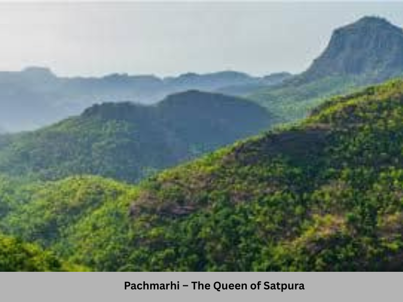
Pachmarhi – Satpura’s marvel
A little south of Sandiya Ghat is the railway station of Pipariya on the Mumbai-Jabalpur-Mughalsarai line. It is the gateway to the British-established hill station of Pachmarhi. Pachmarhi also acted as the summer capital of the British for the Central Provinces (later Central Provinces and Berar) and still has a Raj Bhavan (Governor’s House) and also a second Collector Bungalow of the Narmadapuram district. The height of the plateau on which the town is located is more than 3500 ft. The plateau is almost circumscribed on three sides with higher ranges and is surrounded by quite a few peaks. The most prominent among them are the Dhoopgarh, Mahadev, and Chauragarh. Dhoopgarh, having a height of 4450 feet is the highest peak in Central India (in MP and Chhattisgarh.)
At Pachmarhi, the Satpura rises to its most majestic glory. One can relish great views of sunrise and sunset from Dhoopgarh, as well as breathtaking views of the green valley from near Mahadev and Priyadarshani (a view point named after Indira Gandhi who had visited the area), as also from several other spots. From Chauragarh one gets a view of both the Pachmarhi side as well as the southern ranges of the Satpuras that fall in the Tamia belt of the Chhindwara district. There are hilly ranges and ravines aplenty, full of dense forest covers as far as the eyes can see. No wonder Pachmarhi is called the ‘Queen of the Satpuras.’
The whole of Pachmarhi area is a trekker’s paradise. Its potential to develop as a hill station was first discovered around 1860 by an Englishman named James Forsyth of the Bengal Lancers, who, it is said, had been searching for some revolutionaries of the 1857 battle of independence. Pachmarhi has some old and beautiful British bungalows, many of which have now been taken over by MP Tourism, churches, and graveyard where, thousands of miles away from their land, several Englishmen found their final place of repose.
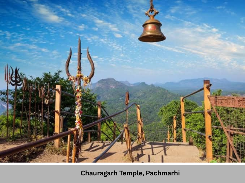
Though Pachmarhi does not fall on the Narmada Parikrama circuit, it is very much a part of the river’s basin and contributes significantly to Narmada through nearby rivulets like Denva, and very importantly through its dense forests that help in arresting soil erosion from the Satpura slopes into Narmada waters. It has three very important Shiva temples visited by hundreds of thousands of people around the year, particularly during the festival of Mahashivaratri. They are the Jatashankar, an underground cave where water drops down the rock ceiling with the rocks inside taking the shape of the Great Lord’s Jata – hairlocks. It is located at the Pachmarhi plateau near the Bazaar. About 10 km away is the Mahadev, with a natural ‘kund’ and the ‘Gupta Mahadev’ – which is reached after a 40 m narrow and dark tunnel – enabling only one person to pass at a time. A couple of miles away or rather upward with about 1700 stairs on the way is the temple of Chauragarh where thousands of ‘Trishools’, varying from small dimensions to those weighing even a quintal or more are offered. Climbing up the Chauragarh can be quite an arduous task. One comes across devoted sons bringing their elderly parents in a palanquin through such a way which can be daunting enough for a person in good health walking even without any personal effects to carry. Similarly one is amazed and also saddened at the sight of extremely poor tribals who cross the hills from Chhindwara district to sell wares or fruits worth a few rupees, with little earning to show at the end of the day. Many of them are children, particularly girls barely in their early teens who ought to have been in schools during those hours.
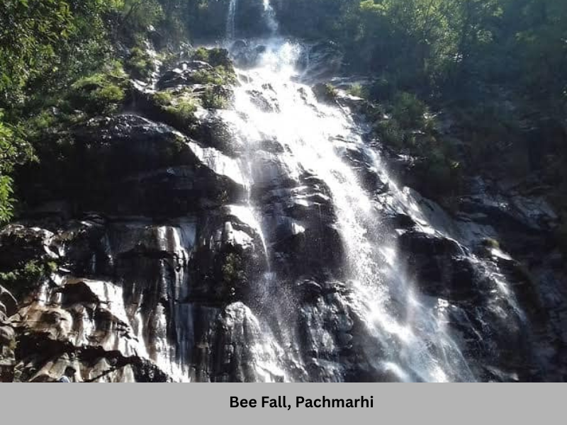
There are several waterfalls, gorges, and hill-peaks in Pachmarhi where one can visit. Prominent among them are the Bee Fall (Yamuna Prapat), the Dutchess Fall (Jalavataran), Silver Fall (Rajat Prapat), and Fairy Pool (Apsara Vihar.) There are Pandava Caves (where the Pandavas are said to have lived during their period of exile). It is these caves that give Pachmarhi its name. The top of the caves is a natural terrace that offers a splendid panoramic view of the Pachmarhi plateau and its periphery. A similar view point is the hilltop garden of “Rajendra Giri’ named in honour of the first President of the Republic, Dr Rajendra Prasad, who had been very fond of the place and felt that the salubrious climate of the area really helped improve his health. He stayed at a hilltop bungalow, now called the Ravishankar Bhavan, named after the first Chief Minister of the state, Pandit Ravishankar Shukla, whose son Shyamacharan was a three-time Chief Minister of the state and Vidyacharan, a Union Minister in many governments.
Pachmarhi has an army establishment and significant presence of Jawans, who can be seen trekking on its roads maintained by the Cantonment Board or the Special Area Development Authority – SADA. Because all the land belongs either to the army or the forest department, no construction or land purchase is permissible in the area. This has, in no insignificant measure, contributed to the pristine charm of Pachmarhi, lost by many other similar areas of natural beauty. In whole of central India, Pachmarhi is one area in Central India where one cannot be left overawed by nature’s supreme majesty. There is a large bio-reserve area around the place called the Satpura National Park. It has a large number of leopards, barasinghas (the state’s official animal,) bisons etc, and the region witnesses occasional movement of tigers too. As far as tourism is concerned, Pachmarhi remains the pre-eminent destination in MP, with a large number of people, visiting the area in summers, not just from within the state but also from Maharashtra, particularly from the city of Nagpur, about 275 km away.
From the periphery of the Pachmarhi plateau flows down the river Denwa which meets Tawa, a very important tributary of Narmada. During its trajectory it flows through a ravine, just about 20 kilometres below Pachmarhi, offering a wonderful view called ‘Denwa Darshan.’ The Denwa carries a lot of sand, formed through thousands of years of flow down the hills, and is very favourable for growing of melons. The whole of Pachmarhi region is rich in a wide variety of fruits. Its mangoes are said to be of very high quality and sought after by bears and humans alike. The government’s horticulture department maintains a number of fruit gardens in Pachmarhi, and a bit lower down at Pagara, and Matkuli.
The river Barna (having the Pauranik name of Vaaruna) flows from the hills of Vindhya in Bari-Silwani region of the Raisen district, and meets Narmada on the northern banks at a place called Bagalwada where there is a temple of Vaaruneshwara Mahadeva. There is also a dam on the Barna river. The hills of Vindhya are densely forested in this area of Raisen district, where the town of Bari is located at the foothills with several temples around the area.
A little downstream of Barna-Narmada confluence is a place called Motalsar where Devarshi Narada is said to have done Tapasya. Here the rivulet Naradi meets Narmada.
Further downstream on the same side, is also a prominent ghat on Narmada called Bharkachha where Rishi Bhrigu had done Tapasya. There is yet another spot associated with Rishi Bhrigu called in Pauranik times as Bhrigukachha, which is now the modern town of Bharuch in Gujarat, falling almost at the end of Narmada’s trajectory and the last district in its course. We shall come to it in due course. Just near Bharkachha is the village of Kusumkheda which has a grand Satyanarayan temple.
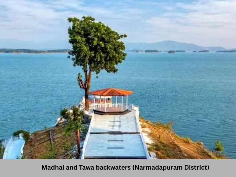
A little downstream, at Bandrabhan, Narmada meets its important tributary Tawa, on the southern banks. Tawa, 172 km in length, which originates from Satpura in Betul district and as it approaches the meeting point it widens very considerably and has a rich sandy bed. Tawa has two dams on it. The first is near the Thermal Power Plant and coalfield of Sarani and its water is used to service the power plant. But it has a second and a considerably larger number dam reservoir amidst very scenic backwaters with deep forested Satpuras on the larger part of the periphery, with Pachmarhi’s high peaks on the east. The Tawa dam backwaters have developed into a prominent tourism site called Madhai, and expensive tour packages are offered that include stay, jungle safaris, trekking etc. The forests in this part of Satpura are rich with wildlife and are preserved in form of Satpura reserve forests. The Tawa becomes very wide and has the longest riverine road bridge in MP between Narmadapuram and Babai – the birth place of the renowned Hindi poet Makhanlal Chaturvedi, whose poem ‘Pushp ki Abhilasha’ is read by every school-going child in the Hindi belt and whose literary works like ‘Him Kiritini’ and ‘Him Tarangini’ that have enriched Hindi literature. There is now a major university of Journalism in name of Makhanlal Chaturvedi located in Bhopal.
South of Narmadapuram are Chhindwara and Betul districts, large parts of which are forested and fall in the Narmada basin. Chhindwara has a geographical spectacle of Patalkot where a particularly vulnerable tribe of Bhariya live in small hamlets, more than 1000 feet below the plateau surface in a valley surrounded by hills on three sides. That explains its name which literally means the nether land. Sun is visible only for a limited hours in some parts of Patalkot and till recently it was common for the ill and incapacitated to be taken in palanquins to the main surface above for any hope of medical treatment. The scenic town of Tamia is also nearby on another Satpura range just behind the Pachmari and Mahadev-Chauragarh hills. Much of the water from this area also finally flows into the Narmada.
From Multai in the Betul district, which is west of Chhindwara, originates the Tapti, the other major peninsular river flowing into the Arabian Sea. It has its own basin on the southern ranges of the Satpuras in Betul and Khandwa districts before it enters Maharashtra. It does not have much water on its trajectory in MP but gains substantially helped by the tributaries in its course through Maharashtra. It becomes quite voluminous when it finally meets the sea immediately after the city of Surat, said to be the world’s fastest growing city at present. Surat served as an important port in bygone times and there is little doubt that Tapti had a role in transporting of goods from inland areas to the port.
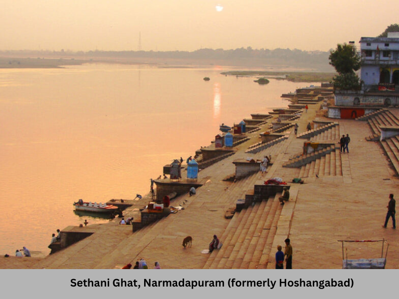
The district headquarter Narmadapuram (till recently called Hoshangabad) after Nawab of Mandavgarh Hoshang Shah, who died here, is an important town on Narmada. It has a beautiful ghat called the ‘Sethani Ghat’ built by the family of one Srimati Jaanaki Sethani in 1881. The Sethani Ghat has several temples and places for stay of Parikramavasis. There are Kathas, Pravachans and religious functions going on at the Ghat, giving it an ambience not unlike the Dashashwamedh Ghat of Varanasi. People perform Narmada Arati at the Ghat, which again recalls to the mind the Ganga Arati at Varanasi. There is a prominent place called Narmada Satsang Bhavan which regularly holds religious congregations.
The Vindhyas are close by, very near to the northern banks of the Sethani Ghat with Guljari Ghat in Sehore district, exactly opposite to it. The Satpuras, though, recede some distance away. The Sethani Ghat draws a lots of people, even from the city of Bhopal, situated up the Vindhyas at a distance of 75 km. The city of Bhopal is now largely supplied with water from Narmada through pipes which take the water to the plateau on which the city is located at a height of 1600 feet. Interestingly the city, does not fall in the Narmada basin, as its water drains into Betwa (earlier called the Vetravati) that eventually joins the Yamuna and thus, finally, through the Ganga, is carried into the Bay of Bengal. Therefore, the state capital, a fast growing city for last several decades, merely uses the Narmada, without contributing anything to it. But then Narmada, like a quintessential uncomplaining mother, has ‘giving’ as her primary nature.
The town of Narmadapuram has the Security Paper Mill where the paper of currency notes is prepared. The currency notes are printed in the nearby town of Dewas and also in Nasik at establishment called the Bank Note Press. Just 18 km south of Narmadapuram is the major railway junction of Itarsi – one of the most important junctions in the whole country. One can catch a train to almost any part of India from this junction. It was also the hometown of noted Hindi litterateur Harishankar Parsai. Narmadapuram also gave another Hindi literature stalwart, Bhavaniprasad Mishra. The town of Narmadapuram has a strong claim to be called the cultural capital of the central Narmadakhand.
On the northern banks, downstream of the Raisen district is the Sehore district. A beautiful ghat is at Bandrabhan, which was earlier called the ‘Bandar-Bhaloo Teertha.’ The small village of Jait, a little upstream of Bandrabhan also has a reasonably sturdy ghat and is now known widely in the region, for its local boy, Shivraj Singh Chauhan, holding the office of Chief Minister for the longest time in the state’s history.
A little further downstream of Narmadapuram but on the opposite (northern) banks is the town of is Budhni (also in Sehore district.) It also has a nice ghat and several temples and places of stay for Parikramavasis at the ghat itself. Budhni is situated on the Bhopal-Narmadapuram section of the Grand Trunk – the Delhi-Chennai (or any southbound railroad) and has a scenic campus of the Central Institute of Farm Machinery at the foothills of the Vindhyas.
The Vindhyachal closely guard the Narmada in this area kilometre patch while Satpura recedes some distance away. Both of them would dutifully accompany Narmada till it enters Gujarat in the last leg of its career. Indeed the Vindyas and Satpuras are no less essential to the Narmadakhand as the Narmada herself.
Next Chapter: From Narmadapuram and Omkareshwar